CURRENT AFFAIRS
Get the most updated and recent current affair content on Padhaikaro.com
El Niño
- IAS NEXT, Lucknow
- 15, Apr 2022

Reference News:-
The southwest monsoon is likely to be “normal” in 2022, though rainfall in August, the second rainiest month, will likely be subdued, according to the private weather company Skymet.
Key findings:
- Rajasthan, Gujarat, Nagaland, Manipur, Mizoram and Tripura are likely to be rain deficit throughout the season.
- Northeastern States have a high base-level of rainfall.
- In the South, Kerala and north interior Karnataka would see subdued rainfall in the core monsoon months of July and August.
- On the other hand, Punjab, Haryana, and Uttar Pradesh — key kharif crop regions — and rainfed areas of Maharashtra and Madhya Pradesh would witness “above normal”’ rainfall.
What is ‘Normal’?
“Normal”, according to Skymet, is 98% of the historical average of 88 cm for the four-month stretch from June-September.
Impact of ENSO:
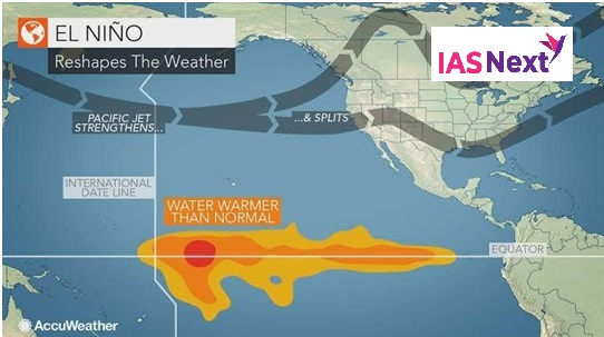
The El Nino, characterised by a warming of temperatures in the Central Pacific and associated with drying up rainfall over India, wasn’t expected to surface this year. Its converse, or a La Nina, had helped with two years of above normal rainfall in 2019, 2020 and “normal” rain in 2021.
What are the Niño and La Niña?
They are two natural climate phenomena occurring across the tropical Pacific Ocean and influence the weather conditions all over the world.
- While the El Niño period is characterised by warming or increased sea surface temperatures in the central and eastern tropical Pacific Ocean, a La Niña event causes the water in the eastern Pacific Ocean to be colder than usual.
- Together, they are called ENSO or El Niño-Southern Oscillation.
What causes El Nino?
- El Nino sets in when there is an anomaly in the pattern.
- The westward-blowing trade winds weaken along the Equator and due to changes in air pressure, the surface water moves eastwards to the coast of northern South America.
- The central and eastern Pacific regions warm up for over six months and result in an El Nino condition.