CURRENT AFFAIRS
Get the most updated and recent current affair content on Padhaikaro.com
La Niña effect on Indian subcontinent
- IAS NEXT, Lucknow
- 20, Jan 2022
Reference News:-
Various parts of India, especially North India, have been experiencing a severe cold wave. Warnings for the severe cold waves have been issued in several northern states.
What is a Cold Wave?
A cold wave is different for the plains and the mountains.
- According to the Indian Meterological Department (IMD) if the temperature goes below 10 degree and minimum temperature is at 4.5 degree, it is a cold wave for the plains. The criteria for hills is 0 degree.
- If the temperature is 6.4 degree below normal or down to 2 degree, it is a severe called wave in the plains.
The IMD calls it “a condition of air temperature which becomes fatal to the human body when exposed.”
But Why is it So Cold?
Short Answer: Strong streams of western disturbances running through the northern belt are causing this.
Complex Answer: La Nina.
- What brings cold to the region, is the unabated north-westerly winds which bring chilly winds from higher latitude to Indo-Gangetic plains. However, passage of back-to-back western disturbances tend to change the wind direction from cold north-westerlies to warm and humid easterlies. However, with La Niña in place, what is expected is less amount of winter rains and thus, icy cold winds would continue to blow over Northwest India uninterruptedly, bringing down the temperatures.”
Background:
El Nino and La Nina are part of the El Nino Southern Oscillation (ENSO) cycle.
- In 2020, La Nina developed during the month of August and then dissipated in April 2021 as ENSO-neutral conditions returned.
- For the upcoming winter season, which extends from December 2021 through February 2022, there is an 87% chance of La Nina.
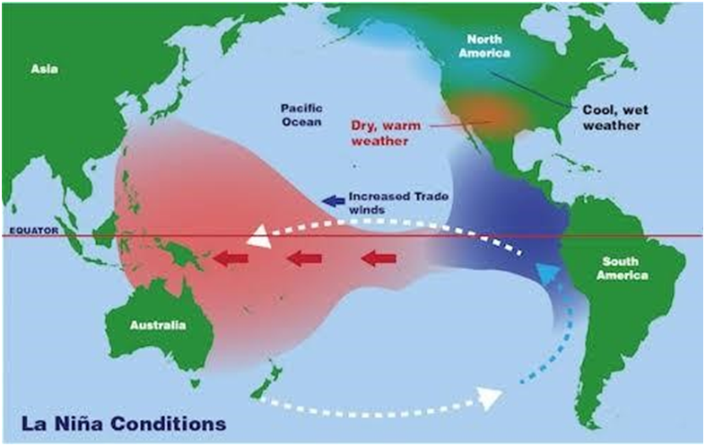
What are the Niño and La Niña?
They are two natural climate phenomena occurring across the tropical Pacific Ocean and influence the weather conditions all over the world.
- While the El Niño period is characterised by warming or increased sea surface temperatures in the central and eastern tropical Pacific Ocean, a La Niña event causes the water in the eastern Pacific Ocean to be colder than usual.
- Together, they are called ENSO or El Niño-Southern Oscillation.
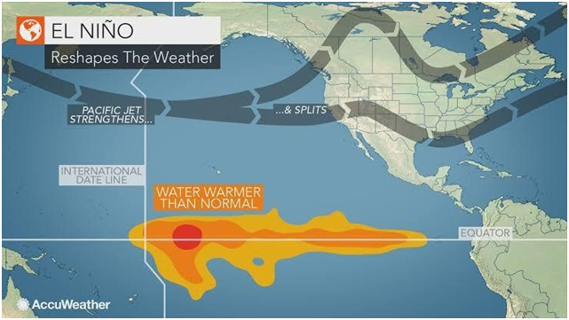
What causes El Nino?
- El Nino sets in when there is an anomaly in the pattern.
- The westward-blowing trade winds weaken along the Equator and due to changes in air pressure, the surface water moves eastwards to the coast of northern South America.
- The central and eastern Pacific regions warm up for over six months and result in an El Nino condition.
Weather changes because of La Nina:
- The Horn of Africa and central Asia will see below average rainfall due to La Niña.
- East Africa is forecast to see drier-than-usual conditions, which together with the existing impacts of the desert locust invasion, may add to regional food insecurity.
- It could also lead to increased rainfall in southern Africa.
- It could also affect the South West Indian Ocean Tropical Cyclone season, reducing the intensity.
- Southeast Asia, some Pacific Islands and the northern region of South America are expected to receive above-average rainfall.
- In India, La Niña means the country will receive more rainfall than normal, leading to floods.